Where am I? How do I find this place? What in the world is this address?! Very common questions while getting around in Japan. Throw out your western understanding of road names, address sequences, etc. They do NOT apply here! I seriously don’t know how anyone survived navigating Japan before GPS. Especially for someone whom the system is so, well, foreign. You may or may not have access to a data connection at all time, or maybe you just don’t want to eat up your battery (me!). This post will give you a quick overview of how addresses in Japan work so you can decipher maps!
Step 1: Where are you going?!
It helps to know where you are heading, train stations make excellent landmarks! It’s

Step 2: Leaving the Train Station – find the map
Did I mention there were maps? Generally speaking, even in rural Japan, you should be able to find a placard with the local area on it either inside the train station or outside the exit. You’ll even find them throughout the cities as well! Keep and eye out for them as they can also lead you to some new discoveries you didn’t know about before. Japan, land of timetables being exact and local conveniences’. And if all else fails, the nice thing, all 7-11s have free Wi-Fi, so if you can find one, you’re golden.

Addresses in Japan: The System
Now, the system for reading addresses in Japan. For starters, there are very few named street names included in addresses in Japan, you will only see them in Kyoto and Sapporo. Sure, some streets have “names”, but they won’t be apart of the address. It’s more of a way to identify different areas.
The hierarchy of addresses in Japan goes from largest land mass to smallest and is as follows:
First, Postal Code
Not as important for getting around but good to mention. 〒stands for postal code in Japan. It’s a seven digit number with a hyphen between the 3rd and 4th numbers.
Second, Prefecture
There are 47 prefectures in Japan, however they all aren’t called that. For those from the states, think “Commonwealth” vs. “state”. There are 43 prefecture proper (県, ken, prefecture), two “urban” prefectures (府, fu, Osaka and Kyoto fall under this), and then one “metropolis” prefecture…bet you can’t guess which. I kid, I kid. Tokyo is Tokyo-都, pronounced tow, not to. Oh, and Hokkaido is it’s own animal with the 道 (dou) ending which usually means “road” or “way” but in this case its “district” prefecture.
So for example, I live in Kanagawa (神奈川) so the first part of my address is
神奈川県.
Third, Municipality
Next we have three possibilities. City (市-shi), or ward (区, ku) in major cities, if you are rural areas you’ll see counties (郡, gun).
Wards aren’t just for Tokyo, side note, she’s got “Special wards”, 特別区. Wards are also more based on population and governing that many people, so it most senses, they are actually “cities” in their own rights and you’ll see the work “city” in their official websites even though they are “wards”. Which confused me for the longest time. Shibuya always has a lot going on and seeing “City of Shibuya” on their official website when they are in the city of “Tokyo”… but also the PREFECTURE of Tokyo…Oh, Japan.
Fourth, Town or Village
The address is then further broken into your “town” within your city, just to be confusing to have all these things stacked on top of each other! You’ll see these as 町 (machi or cho, town) or 村 (son, village).
For example, I use to live in 池田町, Ikedacho, which literally is “pond” “rice field” “town”.
Last, Where #@#%!#$ you are in the neighborhood
These are the chome (丁目 – think of as a neighborhood within the town). Then there is the 番地, banchi which block within that neighborhood and 号, go is for house or building number.
This is the three separated information at the end of an address, “6-36-2” for instance would be 6th chome/neighborhood, 36th block, 2nd house to be built in it. Yes, not in order of location, the order in which they were built. Some wandering may be necessary. Landmarks are important!
The town and chome information are your mainstays once you get to the station you need.
Step 3: Finding way to addresses in Japan – Example
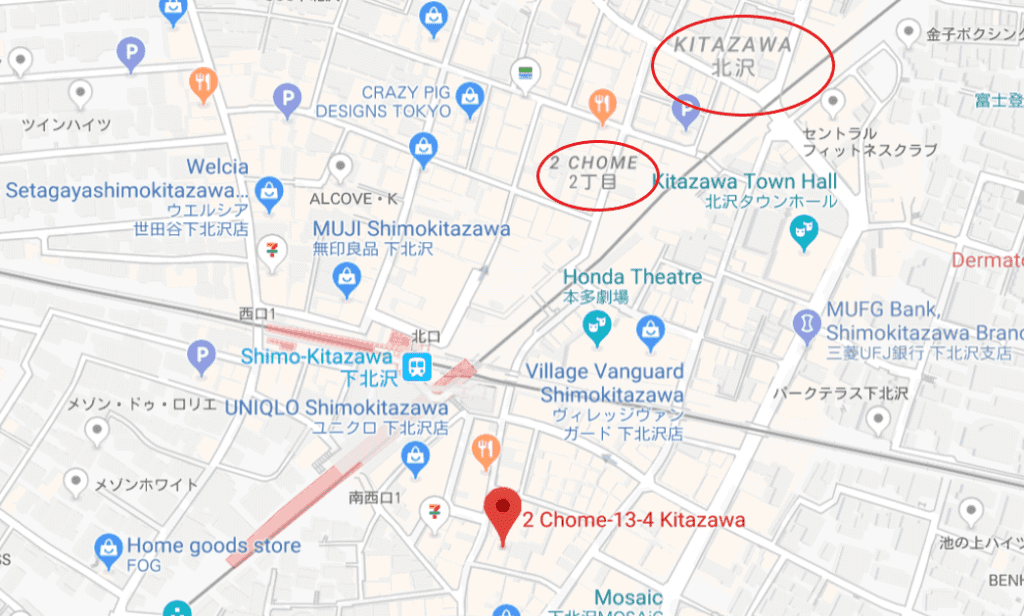
For an example on how to read addresses in Japan, let’s look at how to find a hair salon, or better yet, how about some yummy dinner? Mexican Dining Avocado address is: 東京都世田谷区北沢2-13-4. I know it’s by Shimokitazawa station. Here’s that broken down:
- 東京都 -Tokyo-to, Tokyo Prefecture
- 世田谷区 – Setagaya-ku, Setagaya Ward
- 北沢 – Kitazawa or the “neighborhood” within the ward.
- 2-13-4, “chome” – “block” – “building number”
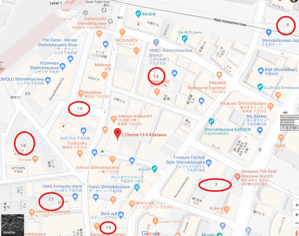
So when looking at a map, first look for Kitazawa (北沢) as there may be more than one town nearby. Second look for a darker number for the chome or neighborhood, it most likely will say “chome” or 丁目. However, sometimes it’s just a bigger number than the block numbers. (To make this easier to read, I took these screen shots from Google but it applies on all Japanese maps).

The block or 番地 is 13 (the area will be boxed in by roads). The blocks are generally in some sort of pattern so this makes it easy to find if you notice one. In this case, blocks 3 to 6 are ascending on the right side, it eventually then drops back down and you see 12 and 14 in the next “row” of blocks. 17, 18 and 19 are then ascending again in the next block.

House or Building numbers you’re on your own. Google doesn’t always mark them correctly, and they don’t follow a pattern, just which was there first. Remember! It’s exciting! You’ll see new places and end up in stopping in some other great places. Otherwise, enjoy the scenery :).
My experience with reading addresses in Japan
In many ways, getting around Japan is an adventure in itself. I love finding my way by landmarks. Which for finding someone’s house, instead of using their addresses in Japan, landmarks are the easiest way. You walk by areas you may not have found because of this. Have fun with it and don’t be afraid to open the door.
Pssst… don’t forget to pin this for later


My brain….
I guess I also never said it was backwards in terms of how western addresses work!